An earthquake registering Mw 7.7 struck Kahramanmaraş’s Pazarcık district at 4:17 a.m. local time on Monday, 6 February 2023. This was followed by numerous aftershocks and a second devestating earthquake registering Mw 7.6, struck the same province’s district of Elbistan nine hours later at 1:24 p.m. Then, a mere two weeks later on 20 February, another earthquake registering Mw 6.4 rattled Hatay’s district of Yayladağı at 8:04 p.m., already one of the most affected provinces by the initial two earthquakes, thereby greatly exacerbating the scope of devastation. The various disruptions and confusion that hampered Türkiye’s response to the February 2023 earthquakes underscore the urgent need of adopting a holistic approach while conducting risk analyses and undertaking damage mitigation works.
The most destructive earthquakes during the Republic of Türkiye’s 100-year history prior to 2023 were, respectively, the 1939 Erzincan and 1999 Izmit earthquakes. However, the February 2023 earthquakes—known internationally as the 2023 Türkiye–Syria earthquakes—surpassed these two previous events both in the extent of area they affected and in the magnitude of loss of life and property they caused. The similarities and differences in the effects of these earthquakes highlight the necessity for developing more robust preventative measures and crafting more comprehensive disaster intervention plans.
Time
The majority of risk analyses either neglect to take into account time altogether or relegate it to a position of secondary importance. Just as time can refer to seasonal or meteorological conditions, it is also an important variable for assessing daily activity patterns. The harsh winter conditions that accompanied the Erzincan earthquake of 27 December 1939 and the February 2023 earthquakes significantly complicated disaster response efforts, resulting in more urgent and dire situations compared to the otherwise catastrophic Izmit earthquake of 17 August 1999. Moreover, the 1939 Erzincan earthquake struck at 1:57 a.m., the 1999 Izmit earthquake at 3:02 a.m., and the 2023 Türkiye–Syria earthquakes at 4:17 a.m., catching much of the local populations, many of whom were still fast asleep in their homes, completely off guard. These three earthquakes coincidentally occurred at a similar time during the day, at the wee hours of the morning, reminding us that future earthquakes can always strike at similar times. Taking a step back and looking a bit more broadly at the most destructive earthquakes of the twenty-first century, we find that the 2004 Sumatra earthquake struck at 8:58 a.m. local time, the 2010 Haiti earthquake at 9:53 p.m., and the 2008 Sichuan earthquake at 2:28 p.m.
Urban activity likewise spikes during certain times of the day, with different parts of a city experiencing more or less traffic depending on specific daily events. Transportation arteries see significantly higher levels of traffic on weekdays before noon, made up largely of individuals on their way to work or school. Traffic again rises in the afternoon when students are released from school, reaching its peak when workers set out on their return trip home for the evening. Come the weekend, however, we observe surges of vehicle traffic and human activity around recreation areas, shopping centers, cultural venues, and restaurants. The intensity of this activity does depend largely on the weather and prevailing seasonal conditions. Traffic between cities, for instance, is particularly high during summer months and holidays, periods that similarly coincide with a substantial influx of tourists. While domestic tourists may be aware of the risks associated with the areas they visit, their foreign counterparts often lack such knowledge. Furthermore, language barriers place foreign tourists in an even more precarious situation should a disaster strike.
Another issue affected by time is the updating of census and land use data. Advances in information and remote sensing technologies allow specialists to compile and analyze detailed reports that would have only come into existence after weeks, if not months, of tedious field surveys in the last century. Databases must be kept as up to date as possible so that alternative intervention plans may be developed in accordance to ever-changing urban and regional risk levels.
Root Causes
Analyses of disasters’ root causes demonstrate that problems extend beyond issues of structural integrity, encompassing political, economic, and social dimensions. Mitigating risks and instilling a culture of disaster preparedness require sustained, long-term efforts. Moreover, whether specific regulations have their intended effects often becomes apparent only in the aftermath of a major catastrophic event. Regrettably, however, adherence to mandated regulations may not always be prioritized in contexts where competing societal demands drown out calls for building disaster-resistant cities and policies follow a more populist trajectory. In order to pinpoint the exact root causes of a specific disaster requires one to discuss causal relationships in light of how such concepts as informal makeshift settlements, immigration, and regional disparities have evolved over time.
Urban risks in Türkiye include problems stemming from land use decisions, rapid urbanization, retroactive zoning amnesty and the high-risk structures permitted to remain standing as a result, and current building inspection
regulations. For instance, Istanbul’s current population of sixteen million people has increased at a rate higher than the national average since the 1980s (see Figure 1). The growing disparity can be attributed to the wider variety of work and educational opportunities that Istanbul offers its inhabitants, largely unavailable in the other parts of Türkiye from which they had emigrated. The flow of immigrants that caused Istanbul’s urban population to grow by roughly 250% during the 1980s greatly strained the city’s already stressed housing situation. Türkiye’s larger cities had already experienced a rise in informal makeshift settlements and unlicensed buildings in the 1950s, many of which avoided government repossession following retroactive zoning amnesty schemes. The construction of residential dwellings and urbanization initiatives following the 1999 Izmit earthquake failed to consider all of the country’s socioeconomic groups, thereby reinforcing the link between poverty and vulnerable structures.
Adana, Gaziantep, Diyarbakır, Şanlıurfa, and Hatay—cities affected by the 2023 Türkiye–Syria earthquakes reveals—all experienced a surge of immigration starting in the 1970s as investments in Türkiye’s industrial infrastructure were incentivized. Urban growth slowly ate more and more away from the agricultural, pasture, and forest areas of these cities. After the year 2000, cities began a process of urban revitalization and transformation to improve public services and utilities and to rehabilitate collapsed urban infrastructure and areas in which unlicensed buildings had proliferated. As a result of these efforts, this period corresponded with a profound increase in urban sprawl and vertical growth.
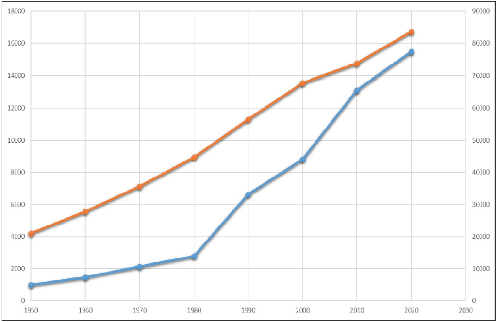
Figure 1 Population increase in Türkiye (orange) and Istanbul (blue) from 1950 to 2020
Cascading Impacts
Studies exploring cascading disasters attempt to predict the potential aftermath of future disasters based on past events. To this end, experts conduct in-depth analyses on factors believed to trigger the initial effect that will unleash a successive chain of events as well as on the vulnerabilities of elements that could be affected by these factors. These analyses not only aid in forecasting how the aftermath of future disasters may pan out but also foreshadow of any potential hiccups during disaster responses and the logistics that support them. While cascading disaster analyses help experts untangle complex webs of effects precipitated by natural disasters, their utility extends well beyond disaster response systems by helping urban planners determine metrics to use while creating effective plans for residential areas exposed to natural hazards.
Natural hazards can cascade into both natural and human-induced disasters. Not only can earthquakes trigger tsunamis, landslides, or other natural disasters, they can instigate fires or explosions in industrial facilities and urban environments. Given this dual-faceted nature, urban and regional risk analyses should be conducted as part of broader integrated hazard analyses, as this will allow for the development of more effective multifactorial response scenarios that take into account the meteorological and temporal considerations discussed above.
Systemic Risks
Systemic risks refer to the negative effects resulting from the degradation or complete collapse of multiple interconnected systems following a disaster. The COVID-19 pandemic serves as a salient case study for understanding such systemic risks. The measures taken to bring the pandemic’s spread under control caused severe disruptions in global production and supply chains. The reason COVID-19 had such profound global effects was because the networks linking countries and cities to one another have grown and merged together to unprecedented levels via globalization. While these networks facilitated the exchange of goods produced in different parts of the world, they also had the potential to amplify local problems by spreading them across vast geographical areas. The underlying causes and effects of global crises demonstrate just how critical systemic risks truly are.
The 1999 Izmit earthquake wrought widespread destruction on Kocaeli, one of Türkiye’s leading industrial centers, which had the adverse affect of driving up prices and disrupting production throughout the entire country. Consequently, the mid- and long-term effects of the 2023 Türkiye–Syria earthquakes are therefore predicted to have similar repercussions. Disasters’ systemic effects on temporary and permanent migration are yet another issue that should be examined, as it is estimated that roughly five million individuals affected by the 2023 earthquakes relocated to Ankara, Antalya, Mersin, and other provinces in Türkiye.
Organization
In addition to the countless legal regulations that were put into effect in the aftermath of the 1999 Izmit earthquake, Türkiye founded the Disaster and Emergency Management Presidency (AFAD) in 2009. Soon thereafter in 2012, AFAD prepared the country’s first national-level response plan, Türkiye’s Disaster Response Plan (TAMP). While this plan did indeed increase Türkiye’s national capacity to stage coordinated responses, several gaps remain in its implementation at the local level. The discrepancy between this top-down disaster response system and the local means to bring these plans into fruition has resulted in efforts having largely remained on paper without being translated into reality. Consequently, local governments cannot be considered full participants in the disaster response system. Indeed, the governments of most small and medium-sized communities struggle to fund municipal projects, let alone those necessary to ensure the smooth executing of disaster response plans.
Conclusion
Earthquakes not only inflict massive physical damage to residential areas but also trigger widespread systemic shocks by disrupting highly interconnected urban networks. The fact that cities and urban systems are comprised of dynamic structures necessitates that studies conducted in this field take into account time-dependent trends and changes.
While the legal regulations enacted and organizational models developed in the aftermath of the 1999 Izmit earthquake played a crucial role in defining risk mitigation and disaster response procedures, the collaborative milieu in which multiple stakeholders can collectively engage in research and development to produce and implement solutions has yet to manifest its full potential.
1 PARATUS. (2023). D.1.1.Report on participatory workshops in the four application case study sites, including impact chains diagrams for each analysed event https://www.paratus-project.eu/
2 İ.T.Ü. (2023). 6 Şubat 2023 depremleri nihai rapor https://haberler.itu.edu.tr/haberdetay/2023/03/24/itu-den-2023-nihai-deprem-raporu
3 Kundak, S. (2023). Resilience in the shadow of systemic risks. Journal of Design for Resilience in Architecture and Planning, 4(1), s. 51-64. https://doi.org/10.47818/DRArch.2023.v4i1079
4 Göksu, Ç. ve diğ. (2023). A comparative impact chain analysis of 1999 Kocaeli and 2023 Kahramanmaraş earthquakes. Journal of Design for Resilience in Architecture and Planning, 4 (Special Issue), s. 51-64. https://doi.org/10.47818/DRArch.2023.v4si109.